Little Lehigh Watershed
 Click image to view larger.
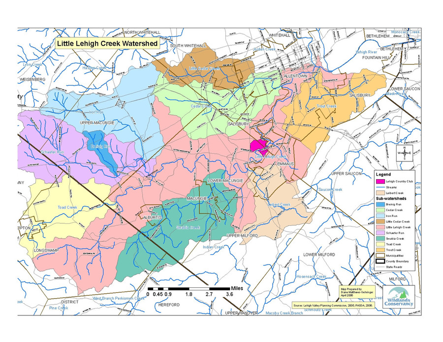
The Little Lehigh Creek is a rapidly developing, 181 square-mile watershed in both Lehigh and Berks Counties that includes the 82 square-mile Jordan Creek sub-watershed. The Little Lehigh Creek mainstem watershed is a highly developing valley primarily underlain by highly permeable carbonate geology, while its Jordan Creek tributary originates in the much less permeable rocks in the northern part of the watershed.
Population of the watershed is well over 200,000 people. The watershed consists of 297 total miles of streams, of which 244.8 miles are classified by PADEP as High Quality for purposes of protection.
PADEP, 2009. Supporting Documentation Little Lehigh Creek, Lehigh and Berks Counties, Nomination for Critical Water Planning Area Under Pennsylvania State Water Plan.
=======================
The Little Lehigh Creek flows into the Lehigh River. Once the Little Lehigh Creek enters the Lehigh River, the water travels 16 miles before it empties into the Delaware River. The main stem of the Little Lehigh Creek ranges from five to 125 feet in width. Approximately 18.7 square miles of the drainage basin are located in Berks County and 88.8 square miles of the drainage basin are located in Lehigh County.
The Little Lehigh Creek flows from Topton in Longswamp Township, Berks County, through Lower Macungie Township and Salisbury Township, until it converges with the Lehigh River in the City of Allentown, Lehigh County. Tributaries drain Upper Macungie Township, Upper Milford Township, Alburtis and Macungie Boroughs and South Whitehall Township.
Land Use & Soils
The land use in the Little Lehigh Creek watershed varies. Most of the land in the headwaters of the Little Lehigh Creek is rural forested land, vacant, or used for agriculture. As the creek flows towards Emmaus and Allentown, residential housing becomes more plentiful and an urban landscape dominates. A fish hatchery is located on the Little Lehigh Creek in the City of Allentown’s Lehigh Parkway park. Some industrial and commercial use can also be found in the eastern portion of the watershed.
Historically, residential growth was limited mostly to the Allentown area due to the lack of access to public sewer systems. When more public sewer systems were built in the 1970s, the rest of the watershed in- creased in population, especially in Upper and Lower Macungie Townships, Lehigh County.
Despite the prosperous growth of the City of Allentown, General Harry C. Trexler around 1900 encouraged the City of Allentown to preserve land in the city. Today, known as the father of Allentown's park system, The Trexler Trust continues to provide funds to maintain the City's expansive park system. A well-loved outdoor gathering area for residents, Allentown’s Lehigh Parkway park meanders along more than three miles of the Little Lehigh Creek, creating a critical refuge for wildlife. The Lehigh Parkway is part of the Delaware-Lehigh State Heritage Park and the Delaware-Lehigh National Heritage Corridor. The National Trail System designated The Lehigh Parkway Heritage Trail that meanders along the creek as Trail No. 689.
There are also protections in place in the headwaters where parcels for homes must be purchased in four-acre parcels. However, much higher density development is permitted in the majority of the watershed. Lower Macungie Township, however, prohibits development in the 500-year floodplain in their municipality. Therefore, much of the 500-year floodplain in the Lower Macungie portion of the Little Lehigh has been donated by developers of adjacent lands to the township. The township protects the 500-year floodplain lands in its possession as open space natural areas.
Some land issues currently affect the state of the Little Lehigh Creek. Many roads cross the Little Lehigh Creek over historic bridges that can no longer adequately accommodate high water flows. Bridges often create stream and floodplain encroachments that can impede water flow, debris and sediment transport. Another concern in the Little Lehigh watershed is the local geology. Much of the underlying geology is carbonate bedrock that creates challenges regarding the possibility of sinkholes forming or groundwater contamination occurring.
Stream Use & State of the Streams
Federal, state and local laws protect the Little Lehigh Creek. The Environmental Protection Agency implements the Safe Drinking Water Act to ensure communities have reliable potable water. The federal 1972 Clean Water Act was enacted to create fishable and swimmable waters by 1983 and eventually eliminate polluted discharges from entering waterways. This ambitious Act has not met its goals, although most states have made great progress.
The Little Lehigh Creek has been used as an important source of drinking water for generations. The creek water once treated, supplies drinking water to more than 130,000 residents in the City of Allentown. The City of Allentown documents the water quality annually in a report and in 2006 the drinking water met all federal and state standards for safety. Wells and springs in the headwaters, as well as an interconnection to Allentown’s water system, provide drinking water to residents in the watershed outside of the City of Allentown.
To protect Pennsylvania’s streams and in order to meet the obligations of the Clean Water Act, Pennsylvania Department of Environmental Protection (PADEP) enacted the Clean Streams Law. Staff from PADEP classify each creek and determine the stream’s designated use (aquatic life, fish consumption, potable water supply and recreation). The main stem of the Little Lehigh Creek and its tributaries have all been designated as a “High Quality, Cold-Water Fishery” (aquatic life) by PADEP’s 2006 Pennsylvania Integrated Water Quality Monitoring and Assessment Report.
Fish & Boat Commission Classifications
Further classifications exist, as determined by the Pennsylvania Fish & Boat Commission (PFBC). PFBC stocks the Little Lehigh Creek main stem and tributaries Cedar and Swabia Creeks. The main stem and a few of the tributaries also support wild trout populations, and PFBC classifies portions of the Little Lehigh Creek as “Class A Wild Trout Waters.” This designation refers to “streams that support a population of naturally produced trout of sufficient size and abundance to support a long-term and rewarding sport fishery,” according to PFBC and these areas are not stocked.
PFBC also designated two reaches within the Little Lehigh Creek main stem as “Special Regulation Areas” that allow only catch and release fly-fishing. Much of the City of Allentown’s Little Lehigh remains a popular fishing destination and continues to support naturally reproducing populations of brown trout.
Sections of Little Lehigh Watershed listed as Class A Wild Trout Waters
| Name of Stream | Kind of Fish | Distance of Reach | Location of Reach of Wild Trout Waters |
| Little Lehigh Creek | Brown Trout | 1.8 miles | Smith Lane Bridge (T-476) downstream to Spring Creek confluence |
| Spring Creek | Brown Trout | 1.1 miles | Iron Run/Schaeffer Run junction downstream to mouth at Little Lehigh |
| Iron Run | Brown Trout | 0.5 miles | Turning Leaf Trail Bridge downstream to Mouth (confluence with Spring Creek) |
| Cedar Creek | Brown Trout | 1.3 miles | Bridge on Cedar Crest Blvd downstream to Lake Muhlenberg |
| Trout Creek | Brown Trout | 1.6 miles | Bridge Dixon Street downstream to mouth of Little Lehigh Creek |
Portions of the Little Lehigh Creek Main Stem for Catch and Release Fly-Fishing Only
| Name of Stream | Distance of Reach | Location of Reach of Catch and Release Fly-Fishing Only |
| Little Lehigh Creek | 1.8 miles | From the downstream face of the bridge on T-508 (Wild Cherry Lane) downstream to the upstream face of the bridge on T-510 (Millrace Road). |
| Little Lehigh Creek | 1 mile | From upstream face of Fish Hatchery Road bridge downstream to near the 24th Street bridge. |
United States Geological Survey Gaging Stations
Two USGS gaging stations operate on the Little Lehigh Creek:
1) Data collected since 1945 in Allentown (2.9 miles from the mouth, 0.8 miles upstream of Cedar Creek confluence).
2) Data collected since 1986 in Allentown near Tenth Street bridge (0.9 miles upstream of Jordan Creek confluence).
Wildlands Conservancy and Lehigh County Conservation District, 2007. Little Lehigh Creek Coldwater Conservation Plan.
Helpful Quick Links
Current Stream Conditions
Learn about our Trout in the Classroom Program.
Follow us on Facebook!